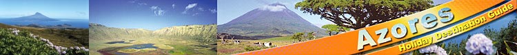
|
Luz, Serra Branca and Serra Dormida, Porto Afonso, Ponta da Barca and Ilhéu da Baleia & Barro Vermelho
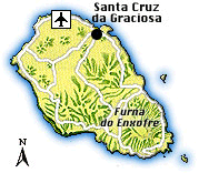
Continuing northwest on the EN1 surrounding the island, the next settlement reached is Luz, a friendly little town with about 800 inhabitants and a 17th-century church, but no further sights to retain a tourist. Located below the crater, it provides some beautiful views across the south coast, where the precipitous white cliffs at Ponta Branca reach heights of almost 300 m.
Next on this route comes the Serra Branca, a range of low hills with a wind park, which can be seen from the road. The wind park - an EU project that was erected with the assistance of German companies – produces about one fifth of the island’s electricity consumption. The Serra Branca’s highest peak is the 360 m high Pico Caldeirinha, a small green-covered crater, from whose top, which can be reached on a short walk, magnificent panoramic views can be enjoyed.
North of the Serra Branca lies the Serra da Dormida, another range of softly undulated low hills – covered with beech-trees, Japanese cedars, heather and other endemic shrubs – the highest peak being the Pico do Timão (398 m) and the second highest the Pico do Facho (371 m), respectively located in the north-eastern and centre part of the serra. Below the pico, on its north side, stretches the island’s largest connected woodland area on a mistério (lava field).
The westernmost point on this route marks Porto Afonso, the old port of the little village of Vitória, extending along the road into the interior of the island. The port is located in a small bay, which is protected by around 100 m high precipitous cliffs and features a curious obelisk-like rock protruding from the ocean. The steep way down to the port reveals views of the different shades of the earth, as the stratums of the cliffs have been laid open with the time. The volcanic rock has weathered so much in this area that it became very crumbly and the boat sheds were rather carved out of the rocks instead of building them with wood. There is not much fishing activity in this port anymore, but during summer months this small bay is popular with bathers and anglers.
Continuing further north, soon the Ponta Barca with its lighthouse towering above the steep, rugged cliffs is reached. East of the Ponta Barca, a tiny rocky islet reminding in its shape of a stranded whale – hence its name Ilhéu da Baleia (‘baleia’ means whale in Portuguese) – rises from the sea.
|
|