|
Graciosa – the white island!
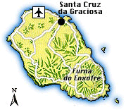
The island of Graciosa, the most northerly of the central group, is located about 80 km northwest of its big sister Terceira. With a surface of 61 sq. km (about 12,5 km length and 8 km width), Graciosa is the second smallest island of the archipelago and it is also the flattest and the driest, with only around 5 % of the island’s surface lying above 300 m and natural water sources being scarce. The island’s maximum altitude of 402 metres is reached at a peak on the eastern edge of the Caldeira, a huge crater dominating the south-eastern part of the island.
The ‘graceful’ island – which probably took its name from its charming, softly undulating landscapes, marked by a few ranges of low mountains, or rather hills, and small volcanic cones, most of them not even reaching the 100-metre mark – has a populated interior in contrast to the other islands of the archipelago. Its epithet ‘the white island’, it probably received due to the light-coloured rocks on its south coast where the foothills of the Serra Branca precipitate into the sea.
Graciosa’s landmarks are doubtlessly the Dutch-style windmills with their peculiar onion-shaped red caps, considered the prettiest of the whole archipelago, especially when their wings are draped with cloths – which unfortunately today is not much seen anymore. There were about 30 of them some time ago; a lot have been renovated in the last years and today there are around four, which are still functioning.
Historically seen, Graciosa’s fate has always been closely linked with those of its neighbours Terceira, Faial, Pico and São Jorge, from where it was also discovered in the mid-15th century. Settling started in the years following its discovery, with the first settlers coming from Portugal mainland and due to its rich soil and the soft relief of its landscapes as well as the fact that Graciosa was to a large degree spared by big nature catastrophes, agriculture was soon thriving, with the main crops being cereals and vines.
As usual in those times, the fame of the island’s prosperity attracted many corsairs and required the protection of its coasts, resulting in the construction of a defence belt, comprising not less than 13 forts. The island’s economic wealth reached its climax during the 18th century when the pirate raids lessened and it became the biggest cereal and wine producer of the archipelago. Yet, in the second half of the 19th century, the island’s good luck changed, as the vineyards were devastated to a large extend by the phylloxera decease and many winegrowing families were deprived of their basis of existence. This caused a big emigration wave to the United States and Canada during the 20th century, cutting the island’s population almost in half.
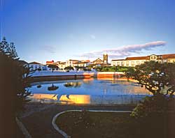
Today, the remaining less than 5,000 inhabitants still make their living mainly out of agriculture, viticulture and cattle raising, with dairy farming taking up the top position of the island’s income sources. The seat of Graciosa’s administration is located in the charming little town of Santa Cruz da Graciosa, where about 1,800 of the island’s actual population live; it received its town charter already in 1486 as a result of its growing economic value due to exceptional agricultural produce.
|
|