|
Faial – the Blue Island!
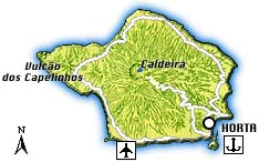
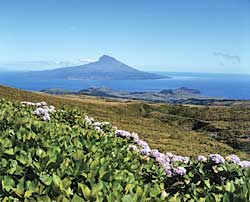
The ‘Ilha Azul’ (‘Blue island’), as Faial is often called because of its countless hydrangea hedges encountered everywhere on the island, is without doubt one of the most charming islands of the Azores. With a shape that resembles an irregular pentagon, Faial covers a surface of approx. 173 sq. km (21 km long and 14 km wide at its most extreme points), which makes it the archipelago’s fifth largest island. The distances to its neighbours are around 7 km to Pico, 19 km to São Jorge, 85 km to Graciosa and 124 km to Terceira.
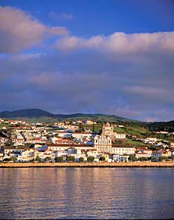
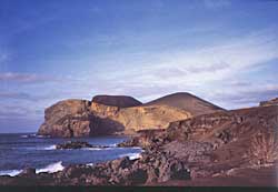
Topographically dominated by the Caldeira, a huge crater with a diameter of about 2 km and a depth of 400 m, featuring gentle slopes intercepted by secondary volcanic formations and the island’s highest peak, reached at Cabeço Gordo, a since 1672 dormant volcano with an altitude of 1,043 m. However, Faial’s biggest attraction is surely its capital, the delightful town of Horta with its famous yacht harbour and a rich architectonic patrimony – probably the archipelago’s liveliest town with a very distinct cosmopolitan flair.
With regard to Faial’s history it can be said that to a certain extent it mirrors the history of the whole archipelago and shows clearly that all historic developments were initiated from the outside. The discovery of the island is closely linked with that of São Jorge in 1450 and settling kicked off on a large scale in 1466 when the Flemish nobleman Josse van Hurtere – after whom the town of Horta was named – arrived on the island together with around thousand fellowmen in search of silver and tin deposits. When the search for these precious metals proved unsuccessful, the settlers started cultivating the fertile land instead, concentrating on wheat as well as pastel and archil. Especially the flourishing export of the dye plants to Flanders and England brought some wealth to the island, which – as well as the fact that Spanish ships laden with riches also used Horta as port of call on their return trip from the colonies – attracted many corsairs and Faial was pillaged severely several times during the 16th and the 17th centuries. Other setbacks in those times were a monstrous eruption of the Cabeço do Fogo in 1672 and a series of devastating earthquakes. Yet, the inhabitants recovered from these blows always quite rapidly, not least because of their continuous exploitation of the neighbouring Pico Island, whose administration was always conducted by Faial.
In the middle of the 18th century, the first American whalers introduced their business to the island and whaling became an important source of income for the islanders. Another mainstay of the island’s economy was the cultivation and exportation of oranges until 1860 when a mycosis destroyed the orange plantations. When the first telegraphic cable was laid from Lisbon to Horta and then, in 1900, the connection with Nova Scotia in Canada was made, Faial – or better Horta – developed into the centre of telegraphic communication between the Old and the New World and many international communication companies settled in Horta, making Faial the most progressive island of the Azores.
Another milestone in Faial’s history was the landing of the first hydroplane in the port of Horta in 1919 and until the 2nd World War all transatlantic flights per hydroplane used Horta’s harbour for a stopover. Faial also became an important military base for the Allies during the 2nd World War. Then, under Salazar’s regime, Faial sank into oblivion like all the other islands of the archipelago. Only when Faial got its airport in 1971 and the Azores Islands were declared ‘autonomous region’ – where Horta was granted the seat of the parliament in 1976, as it became one of the three regional administration centres, Faial’s political and economic importance grew again. Yet, this period of prosperity only lasted until the island experienced another major setback with the terrible earthquake in 1998, which left the island with considerable damages, especially in the northwest, where several villages were almost entirely destroyed.
|
|