|
|
|
|
|
|
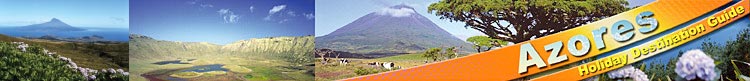
Santa Maria – the yellow island!
Santa Maria, the southernmost and third-smallest island (18 km long and almost 10 km wide; surface approx. 97 sq. km) of the Azores archipelago, belongs to the ‘eastern group’ and is located about 85 km south of São Miguel.
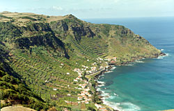
Embellished by a myriad of hues, the island of Santa Maria, evokes a living aquarelle, painted by wide green pastures, yellow crops, the dark ochre of the soils, flowers in multiple colours, pretty white-washed houses and the azure of the ocean in the backdrop. Santa Maria boasts many deep bays, lined with paradisiacal, deserted white sand beaches - considered the most beautiful of the archipelago - and charming, softly undulating landscapes where a serene tranquillity is reigning.
Also of volcanic origin, Santa Maria is the only island in the Azores that has areas of sedimentary origin, explaining the presence of calcareous outcrops (of which a good example can be seen in the bay of São Lourenço) where marine fossils can be found, proofs of successive phases of submersion and emersion since the Miocene. It is also a hilly island, its highest point being the twin peak of Pico Alto (590 m), which flattens out towards the west coast. There are no calderas on the island, whose coastline is predominantly steep, dotted with many cliffs and cut by deep bays and breaches.
The exact date of Santa Maria’s discovery is uncertain, but it is widely believed that it was the first island of the archipelago to be discovered by the Portuguese between 1427 and 1432. A known fact is also that it was the first island to be populated, with Portuguese settlers arriving from the Algarve, Alentejo and Beiras in 1439. Due to the richness of its soils, the island prospered rapidly, which led to the settlement of Vila do Porto on the southwest coast being granted the first market town charter in the Azores in 1472.
During the first centuries after settlement, the island’s richness was based primarily on the cultivation and exportation of cereals to the mainland and the Portuguese strongholds in North Africa. Then, it was the exports of pastel and lichen to Flanders, Spain and England, on which the island’s economy relied completely by the end of the 18th century, this lasting until the pastel experienced a strong competition with the indigo coming from India and Brazil and, the lichen, with the introduction of the chemical dyes. Today, the island’s around 5,600 inhabitants make their living mainly with agriculture - the major crops being vines, corn, potatoes and cereals - cattle raising and fishing and, on a miner scale, in the pottery industry.
|
|
|
|
|
|
|
 |
|
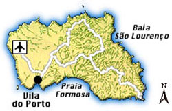
Map of Santa Maria
|
|
 |
|
Bay of São Lourenço
|
|
|
|
|
Praia Formosa
|
|
Due to its strategic location in the Atlantic, in 1944, the American Air Force constructed an airport for military purposes on Santa Maria’s western coast and for a long time, until the airplanes could make the traverse of the Atlantic without refuelling, all transatlantic planes had to make an obligatory stopover on Santa Maria. Since the Americans closed their bases, the airport has lost its importance, and today, it only serves for SATA inter-island flights assuring the daily connection with São Miguel. During the summer months, the island can also be reached by a regular ferry service, about twice a week, from São Miguel.
About 35 km north of Santa Maria lies the Formigas bank, an underground backbone, whose peaks rise as a number of bare cliffs, called Rocas Formigas (‘Ants Rocks’), up to 11 m above sea level. A privileged nesting area for many seabirds, the Formigas have been declared ‘natural reserve’ and their surrounding waters are extremely rich with marine life, which makes it also a very attractive location for big-game fishing.
Boasting the sunniest and driest climate of all the Azores islands, Santa Maria is a genuine alternative for beach holidays for everybody looking for paradisiacal tranquillity!
|
|