|
Flores – the Flower Island
The fourth smallest and most western island of the Azores carries its name Flores (flowers) fully justified due to the myriad of flowers and plants – with many seeds having been carried over from Florida by migrating birds – that grow on this island and make it one of the most beautiful and colourful. Geographically lying on the American continental shelf, the distance to its neighbour island Corvo in the north is about 24 km, to the islands of the central group between 250 and 350 km, depending on their location, and to Santa Maria, the most eastern island of the archipelago, about 600 km. This location so far west in the Atlantic also causes climatic differences to the other islands of the archipelago and although its temperatures remain moderate all year round, Flores has almost twice as much rain and a lot of wind. But there is something good about the rain too, first, it makes Flores the greenest of all the Azores Islands and second, it often leaves behind an enormous rainbow over the island.
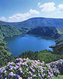
Covering an area of around 143 sq. km (approx. 17 km long and 12 km wide), the island reaches its maximum height of 914 m at the peak of Morro Alto in the north. A genuine paradise for walkers and nature lovers, Flores’ wild, mostly virgin and deserted interior features wonderful serene landscapes marked by high mountains – in some places descending steeply, in others gently, towards the coast – and murmuring streams that often end in spectacular water falls. Picturesque crater lakes, the only reminders of its distant volcanic origin – as well as a few hot sulphur springs – and deep valleys also characterize its landscapes.
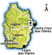
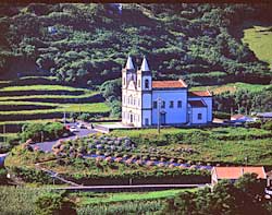
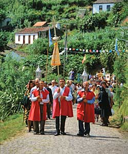
With the village of Fajã Grande on its west coast, Flores also boasts one of the remote points delimiting Europe in the west. The island’s almost 4,000 inhabitants all live in the villages stretching on or above the island’s indented coasts, which are often steep, with jagged cliffs diving into the ocean, where countless tiny rocky islets enhance the coastline almost all around the island. The villages are divided into only two municipalities, Santa Cruz das Flores, the capital located in the centre of the east coast, and Lajes das Flores on the south coast, with the majority of the population living in these two main towns… or rather villages!
Allegedly discovered in 1452 by the seafarer Diogo de Teive on his return from Newfoundland, Flores’ settlement only kicked off on a larger scale towards the end of the 15th century, initiated by a Flemish nobleman, who brought with him cultivated plants and cattle. Yet, like on the other islands, the settlers were initially not interested in traditional farming, but rather in the cultivation of pastel, which was more profitable. The only problem was Flores’ isolated location, with ships only passing on a very irregular schedule, which proved the exportation of the pastel crops very complicated and costly so that cultivation was given up again in the early 16th century. Round about the same time new settlers came – this time from Portugal – who started to work the island’s extremely fertile land with the cultivation of cereals, maize and vegetables. Yet, the difficulties with the exportation of their rich crops remained the same and living conditions did not improve so that many settlers decided to look for better luck in America.
The lack of economic development and progress continued up to the 20th century until whaling, which was brought to the island by American whalers already in 1860, reached its heights in the 1930s. Even if the island’s income improved for a short while, it was not to the benefit of the majority of the population who still lived in great poverty, and emigration continued steadily.
It was only around the middle of the 20th century when modern times started to show on Flores. First it was the Portuguese Navy that erected a base in the southern municipality of Lajes and then the French came and built up a military radio communications station to control the international radio traffic. Subsequently, due to these developments, an electricity and road network was established and in 1986 Faial got finally its airport. But even after that, further development progressed only at a very slow pace and – unimaginable for many of us – it was only in 1986 that TV could be watched for the first time in Fajã Grande! In the meantime, the island has even a cinema, yet emigration continues and has cut down the island’s population by more than half over the centuries…
|
|