|
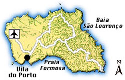
Southwest & East of Vila do Porto
Southwest of Vila do Porto, best seen from a lighthouse in the southwest of the town, which can be reached on a footpath, lies the tiny, about 60 m high Ilheu da Vila, an – togetherx with the surrounding coast - around 65 hectares large protected area for birds.
East of Vila do Porto, a partly overgrown path leads from the ruins of the old hamlet of Touril through savage nature to the remote Baia da Figueiral, a small, unspoilt bay with a natural beach where you can still find marine fossils in the rocks.
A few windmills east of the town, at the 255 m high Pico do Facho produce part of the island’s electricity.
Continuing east along the coast, you will reach the beautiful white-sanded Praia Formosa, one of the best beaches and in summer also the most populated beach in the Azores. Given its outstanding geographical location, it is surprising that this area has not yet seen any major tourism development. Ideal for a little sightseeing, before descending to the beach, are the ruins of the Fortaleza São João Baptista dating from the 16th and 17th centuries; and the Miradouro da Mazela provides beautiful views over the beach and the south coast.
|
|