|
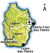
Lajes das Flores & Surroundings
Lajes das Flores, the island’s second municipality, has more of a suburb than of a town, with no real centre and its houses scattering along wide streets at sea level and on the slopes of the backing hill where some are surrounded by pastures and fields.
Due to its natural harbour, Lajes was one of the first settlements on the island and received its town charter already in 1515, long before Santa Cruz. The following centuries were marked by a continuous competition with the other municipality Santa Cruz, which was finally won by the latter when it became the administrative centre of the island. Lajes’ history is not very rich with historic events. Probably only the year 1954 deserves a special mentioning because since then the island lost about half of its population due to emigration.
Today, Lajes’ only importance is based on its natural harbour, whose expansion started during the 19th century, which made Lajes a good base for whale fishing. The whaling industry flourished until the end of 1981 when the last whale was caught and processed in the whaling factory, in the remains of which a whale museum is being created.
In 1994, the newly extended harbour, financed by EU funds, was opened with a new jetty and modern harbour installations to enable freight ships to moor, making Lajes the most important transhipment harbour of the island. A few steps off the harbour, hidden at a river mouth, lies an attractive sand beach. A bit further out of town, an imposing lighthouse that has guided captains westwards with its strong light for centuries stands about 90 m above the sea.
Above the old whaling factory rises the most imposing historic building of the town, the Igreja Matriz Nossa Senhora do Rosário. Built in the second half of the 18th century, this church was renovated several times and, since the 19th century, its sea-facing façade that is dominated by two towers capped by cupolas is covered with tiles. Notable in the interior are a few interesting religious figures, some beautiful paintings and elaborate woodcarvings on the main altar as well as the lateral altars.
Nearby, at the cemetery, is the Ermida da Nossa Senhora das Angústias, which was built in the 18th century by Spanish noblemen in gratitude for their salvation when their ship sunk off Lajes’ coasts.
West of the town, marking the centre of the south coast, you will find the Fajã de Lopo Vaz, the island’s largest and most beautiful beach with dark sand. This magnificent coastal strip, where due to its special microclimate bananas, figs, grapes and pineapples are cultivated, was one of the first areas to be settled.
Another nature attraction west of Lajes is the almost 600 m high Morro dos Frades, peculiarly shaped, these two rocks remind of – when using a lot of imagination – a nun and a monk.
|
|