|
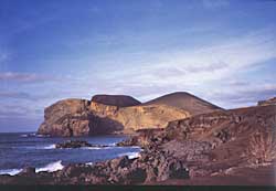
Ponta dos Capelinhos
Strongly contrasting with the rest of the island, Faial’s westernmost point is marked by the Ponta dos Capelinhos, a barren rock desert, which reminds of a lunar landscape and is proof of the most recent volcanic activities on the archipelago. For one whole year, from 1957 to 1958, the off-shore volcano Capelinhos ejected more than 30 million tons of ash and lava more than 1,000 m high into the sky. Devastating results of this long-lasting nature catastrophe were more than 2 km of newly formed land (of which almost half has already been eroded by the sea), a 1 1/2 m thick (at places even 5 m) layer of ash covering the western part of the island and the biggest emigration wave – this time to America – the island ever experienced, as more than 2,000 inhabitants had lost their homes and land.
At the entrance to the tiny village of Capelo, which also had suffered badly during the eruptions of the Capelinhos volcano, lies the Exposição Fotogrâfica Vulcão dos Capelinhos, a comprehensive photographic exhibition, which documents vividly the events during the eruptions from 1957 to 1958.
|
|